
Asheville Hikes
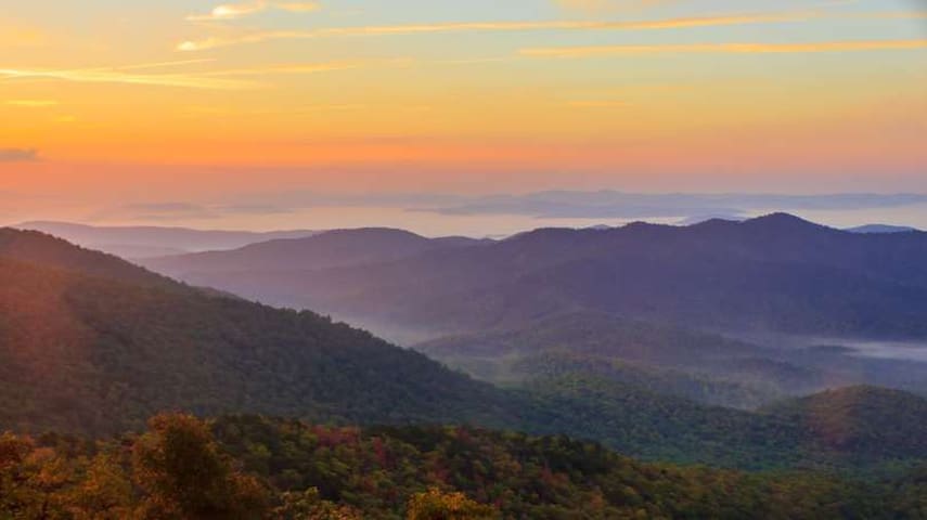
View
Distance: 1.9 Miles
Difficulty: Easy to Moderate
Dog-Friendly: Yes
When the rhododendrons are in bloom, Craggy Gardens is one of the best hikes in Asheville! You get there by driving on the Blue Ridge Parkway (fun!) and you'll hike through a rocky, rhododendron-covered forest with tall grasses, wildflowers, and wild blueberries in the last summer months.
While in the area, you can also hike to the top of Craggy Pinnacle for 360-degree views from the summit, or hike along the Mountains-to-Sea Trail if you're looking to add some miles to your journey!
224 lokalaca preporučuje
Цраги Гарденс центар за посетиоце
364 Blue Ridge PkwyDistance: 1.9 Miles
Difficulty: Easy to Moderate
Dog-Friendly: Yes
When the rhododendrons are in bloom, Craggy Gardens is one of the best hikes in Asheville! You get there by driving on the Blue Ridge Parkway (fun!) and you'll hike through a rocky, rhododendron-covered forest with tall grasses, wildflowers, and wild blueberries in the last summer months.
While in the area, you can also hike to the top of Craggy Pinnacle for 360-degree views from the summit, or hike along the Mountains-to-Sea Trail if you're looking to add some miles to your journey!
Distance: 2.3 Miles
Difficulty: Moderate to Difficult
Dog-Friendly: Yes
If you want more of a workout from your hike, with a view at the top as a reward for the hard work, check out Mt Pisgah!
You'll hike through deciduous forest with wildflowers in warm weather months, and mountain laurel and rhododendron in the early summer.
It's definitely one of Asheville's more popular trails, but the views from the summit’s observation deck worth the trek.
70 lokalaca preporučuje
Mount Pisgah
Distance: 2.3 Miles
Difficulty: Moderate to Difficult
Dog-Friendly: Yes
If you want more of a workout from your hike, with a view at the top as a reward for the hard work, check out Mt Pisgah!
You'll hike through deciduous forest with wildflowers in warm weather months, and mountain laurel and rhododendron in the early summer.
It's definitely one of Asheville's more popular trails, but the views from the summit’s observation deck worth the trek.
Distance: 4.7 Miles (Out-and-Back)
Difficulty: Moderate
Dog-Friendly: Yes
You don't have to go far to get a good hike in Asheville! This top-rated trail on AllTrails follows the Mountains-to-Sea Trail, and starts at the Folk Art Center before heading North to the Haw Creek Overlook, where you'll be rewarded with a nice view of the Haw Creek area.
Pack a picnic if you want to spend a little extra time on the trail, because the area at the end where you have the view is filled with flat rocks that are great for relaxing and enjoying a bite while you soak in the sights.
255 lokalaca preporučuje
The Folk Art Center (Southern Highland Craft Guild)
382 Blue Ridge PkwyDistance: 4.7 Miles (Out-and-Back)
Difficulty: Moderate
Dog-Friendly: Yes
You don't have to go far to get a good hike in Asheville! This top-rated trail on AllTrails follows the Mountains-to-Sea Trail, and starts at the Folk Art Center before heading North to the Haw Creek Overlook, where you'll be rewarded with a nice view of the Haw Creek area.
Pack a picnic if you want to spend a little extra time on the trail, because the area at the end where you have the view is filled with flat rocks that are great for relaxing and enjoying a bite while you soak in the sights.
Waterfalls
Distance: 3.3 Miles
Difficulty: Moderate
Dog-Friendly: Yes
Graveyard Fields is definitely a more popular hike, so it can get a little busy/crowded on the weekends, but if you're seeking waterfalls in the Asheville area, this is a great hike to add to your list.
You'll hike through rhododendron and mountain laurel, as well as wild blueberries and blackberries when they're in season, with two waterfalls along the way: a multi-level 'second falls' and the tall cascades of the 'upper falls'.
If you're looking for even more distance (and a more difficult hike) you can do the full Graveyard Fields Loop, which is 6.15 Miles, and tends to be a little less crowded once you're off the main Graveyard Fields trail.
176 lokalaca preporučuje
Graveyard Fields Loop Trail
Blue Ridge ParkwayDistance: 3.3 Miles
Difficulty: Moderate
Dog-Friendly: Yes
Graveyard Fields is definitely a more popular hike, so it can get a little busy/crowded on the weekends, but if you're seeking waterfalls in the Asheville area, this is a great hike to add to your list.
You'll hike through rhododendron and mountain laurel, as well as wild blueberries and blackberries when they're in season, with two waterfalls along the way: a multi-level 'second falls' and the tall cascades of the 'upper falls'.
If you're looking for even more distance (and a more difficult hike) you can do the full Graveyard Fields Loop, which is 6.15 Miles, and tends to be a little less crowded once you're off the main Graveyard Fields trail.
Distance: 1.2 Miles (Out-and-Back)
Difficulty: Easy
Dog-Friendly: Yes
If you're looking for an easy hike for the family, Moore Cove Falls is a great option!
This wide and well-maintained trail takes you to Moore Cove Falls, a 50-foot-high waterfall that pours over a rock overhang, so you can actually walk behind it while you explore the area.
45 lokalaca preporučuje
Moore Cove Falls
Distance: 1.2 Miles (Out-and-Back)
Difficulty: Easy
Dog-Friendly: Yes
If you're looking for an easy hike for the family, Moore Cove Falls is a great option!
This wide and well-maintained trail takes you to Moore Cove Falls, a 50-foot-high waterfall that pours over a rock overhang, so you can actually walk behind it while you explore the area.
Destination
Distance: 3.8 Miles
Difficulty: Moderate
Dog-Friendly: Yes
If you’re looking for more peace and quiet along your hike, Rattlesnake Lodge is less busy than the average Asheville trail, so it’s a good option.
You'll follow a narrow, historic road to the remains of an estate from the early 1900s, and this hike through the hardwood forest is especially beautiful during the autumn months, when you can see the fall's full range of colors as the leaves change.
16 lokalaca preporučuje
Rattlesnake Lodge
Blue Ridge ParkwayDistance: 3.8 Miles
Difficulty: Moderate
Dog-Friendly: Yes
If you’re looking for more peace and quiet along your hike, Rattlesnake Lodge is less busy than the average Asheville trail, so it’s a good option.
You'll follow a narrow, historic road to the remains of an estate from the early 1900s, and this hike through the hardwood forest is especially beautiful during the autumn months, when you can see the fall's full range of colors as the leaves change.
Distance: 11.9 Miles (Out-and-Back)
Difficulty: Difficult
Dog-Friendly: Yes
If you're looking for a challenge, or a full-day hike, this trail is it!
You'll start at the Black Mountain Campground, north of Asheville along the Blue Ridge Parkway, and follow the Mount Mitchell Trail all the way to the summit, gaining 3,694 ft of elevation as you climb to the highest peak east of the Mississippi River.
At the observation point on the summit, you can see Grandfather Mountain and Table Rock in the distance if the weather cooperates. There's also a little museum, gift shop, snack stand, and restrooms so you can prepare for the hike back down the mountain.
If you want even more of a challenge, follow the three-mile round-trip hike along Deep Gap Trail from the summit of Mount Mitchell to the summit of Mount Craig, the second-highest point in the eastern United States, and you can knock off both of the highest peaks east of the Mississippi in a single day!
12 lokalaca preporučuje
Mount Mitchell Trailhead
South Toe River RoadDistance: 11.9 Miles (Out-and-Back)
Difficulty: Difficult
Dog-Friendly: Yes
If you're looking for a challenge, or a full-day hike, this trail is it!
You'll start at the Black Mountain Campground, north of Asheville along the Blue Ridge Parkway, and follow the Mount Mitchell Trail all the way to the summit, gaining 3,694 ft of elevation as you climb to the highest peak east of the Mississippi River.
At the observation point on the summit, you can see Grandfather Mountain and Table Rock in the distance if the weather cooperates. There's also a little museum, gift shop, snack stand, and restrooms so you can prepare for the hike back down the mountain.
If you want even more of a challenge, follow the three-mile round-trip hike along Deep Gap Trail from the summit of Mount Mitchell to the summit of Mount Craig, the second-highest point in the eastern United States, and you can knock off both of the highest peaks east of the Mississippi in a single day!