
The Great Outdoors
Walking/ hiking trails
Carl Sandburg Home National Historic Site
1800 Little River RdDuPont State Recreational Forest, commonly known as DuPont Forest, is a 12,500-acre state forest, located in Henderson and Transylvania counties of North Carolina.
https://www.dupontstaterecreationalforest.com/
624 lokalaca preporučuje
Државна шума Дупонт
Staton RoadDuPont State Recreational Forest, commonly known as DuPont Forest, is a 12,500-acre state forest, located in Henderson and Transylvania counties of North Carolina.
https://www.dupontstaterecreationalforest.com/
Directly across the street. This park has great walking trails.
40 lokalaca preporučuje
Парк у Флат Року
55 Highland Golf DrDirectly across the street. This park has great walking trails.
Bullington Gardens
95 Upper Red Oak TrailPearson's Falls and Glen
2748 Pearson Falls RdA challenging hike.
Lately there has been trail work going on, so check to see if it is open before you go.
43 lokalaca preporučuje
Big Bradley Falls
A challenging hike.
Lately there has been trail work going on, so check to see if it is open before you go.
For the History Buff
Carl Sandburg Home National Historic Site
1800 Little River RdMountain Biking trails
Excellent walking/ Hiking and mountain biking trails with great views and some with waterfalls.
DuPont State Recreational Forest, commonly known as DuPont Forest, is a 12,500-acre state forest, located in Henderson and Transylvania counties of North Carolina.
https://www.dupontstaterecreationalforest.com/
624 lokalaca preporučuje
Државна шума Дупонт
Staton RoadExcellent walking/ Hiking and mountain biking trails with great views and some with waterfalls.
DuPont State Recreational Forest, commonly known as DuPont Forest, is a 12,500-acre state forest, located in Henderson and Transylvania counties of North Carolina.
https://www.dupontstaterecreationalforest.com/
Pisgah National Forest
Bent Creek trailhead
2-1298 491https://www.mtbikewnc.com/trailheads/bent-creek/
Ride Kanuga
1249 Kanuga Lake Rdhttps://ridekanuga.com
https://www.blueridgeparkway.org/members/chimney-rock-at-chimney-rock-state-park/
333 lokalaca preporučuje
Државни парк Чимни Рок
431 Main Sthttps://www.blueridgeparkway.org/members/chimney-rock-at-chimney-rock-state-park/
Ridgline is one of the fastest, flowiest downhill rides in the area. This is a nice, quick 6-mile loop that finishes with a great downhill.
Start at the Lake Imaging parking area and wind around to climb the Jim Branch Trail. This beautiful forested climb comes up to a saddle where you'll take a quick ride over the Isaac Heath trail and will dump you out on Buck Forest Road where you'll take a left.
The next right is Thomas Cemetery Road, where you'll follow this gravel road all the way until it changes over to White Pine Trail. At the top of White Pine, take a left on Hooker Creek Trail and get ready for a super-fast downhill that will leave you smiling. Then another quick climb where you'll catch Ridgeline to take a left and hang on.
The fast and flowy descent will take you through some berms, a log ride, and many fun dips and corners. Watch out for horse poop on the trail though!
https://www.dupontstaterecreationalforest.com/
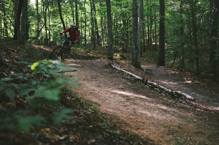
Ridgeline Trail
Ridgeline TrailRidgline is one of the fastest, flowiest downhill rides in the area. This is a nice, quick 6-mile loop that finishes with a great downhill.
Start at the Lake Imaging parking area and wind around to climb the Jim Branch Trail. This beautiful forested climb comes up to a saddle where you'll take a quick ride over the Isaac Heath trail and will dump you out on Buck Forest Road where you'll take a left.
The next right is Thomas Cemetery Road, where you'll follow this gravel road all the way until it changes over to White Pine Trail. At the top of White Pine, take a left on Hooker Creek Trail and get ready for a super-fast downhill that will leave you smiling. Then another quick climb where you'll catch Ridgeline to take a left and hang on.
The fast and flowy descent will take you through some berms, a log ride, and many fun dips and corners. Watch out for horse poop on the trail though!
https://www.dupontstaterecreationalforest.com/
WEST SIDE TRAIL- Hiking/ Biking
Big climbs, big downhills, and gorgeous scenery! This is an advanced-intermediate tour of the western side of Dupont State Forest. It covers about 20 miles with 2100+ feet of elevation change.
This route covers most of the west side of Dupont (park at Corn Mill Shoals parking lot). If short on time, you can skip the second loop to Reasonover Creek and just do the three western-most loops. The entire route consists of four main loops.
Loop 1 is a clockwise loop of Burnt Mountain. This is a great warmup loop with a steep but relatively short climb followed by some fun downhill. Good mix of flowy and technical terrain.
Loop 2 has a RIVER CROSSING at the beginning and end. (You'll have to cross the river twice so be prepared to get wet. If short on time or if you simply don't want to cross a river, you can skip this loop and move onto loop 3.) Loop 2 takes you east and covers Laurel Ridge, Mine Mountain, Reasonover Creek, Airstrip Trail, and then brings you back to Corn Mill Shoals Trail. This loop has a great mix of terrain and will bring you by Lake Julia (great spot to take a break down by the water) and includes a great downhill at Airstrip Trail.
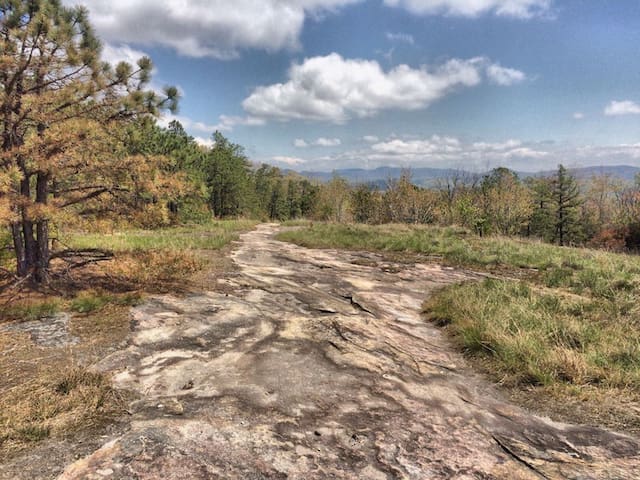
Loop 3 is the most challenging and has the most climbing. It will take you up Cedar Rock to Big Rock and back down. You'll be climbing mostly rock on the way up with some water flowing in some spots. At the top you'll see nice views from Big Rock and then have a really fun and rocky downhill back towards the parking area. At this point you can decide whether you have enough left for Loop 4 or if you should just head back to your car.
Loop 4 is a great cool down loop. Rather than head back to the parking lot, you hang a right on Longside which will take you through some fun terrain and connect you to Pine Tree and Cascade. This loop is a great change of pace (and scenery) from Big Rock and a nice way to end your ride.
Description by MRBproject
https://www.dupontstaterecreationalforest.com/
624 lokalaca preporučuje
Државна шума Дупонт
Staton RoadWEST SIDE TRAIL- Hiking/ Biking
Big climbs, big downhills, and gorgeous scenery! This is an advanced-intermediate tour of the western side of Dupont State Forest. It covers about 20 miles with 2100+ feet of elevation change.
This route covers most of the west side of Dupont (park at Corn Mill Shoals parking lot). If short on time, you can skip the second loop to Reasonover Creek and just do the three western-most loops. The entire route consists of four main loops.
Loop 1 is a clockwise loop of Burnt Mountain. This is a great warmup loop with a steep but relatively short climb followed by some fun downhill. Good mix of flowy and technical terrain.
Loop 2 has a RIVER CROSSING at the beginning and end. (You'll have to cross the river twice so be prepared to get wet. If short on time or if you simply don't want to cross a river, you can skip this loop and move onto loop 3.) Loop 2 takes you east and covers Laurel Ridge, Mine Mountain, Reasonover Creek, Airstrip Trail, and then brings you back to Corn Mill Shoals Trail. This loop has a great mix of terrain and will bring you by Lake Julia (great spot to take a break down by the water) and includes a great downhill at Airstrip Trail.
Loop 3 is the most challenging and has the most climbing. It will take you up Cedar Rock to Big Rock and back down. You'll be climbing mostly rock on the way up with some water flowing in some spots. At the top you'll see nice views from Big Rock and then have a really fun and rocky downhill back towards the parking area. At this point you can decide whether you have enough left for Loop 4 or if you should just head back to your car.
Loop 4 is a great cool down loop. Rather than head back to the parking lot, you hang a right on Longside which will take you through some fun terrain and connect you to Pine Tree and Cascade. This loop is a great change of pace (and scenery) from Big Rock and a nice way to end your ride.
Description by MRBproject
https://www.dupontstaterecreationalforest.com/